Discursive on the Gamburtsev

To Climb These Mountains, You Need to Dive
Gamburtsev

The Gamburtsev Discursive

There's a mountain range on Earth that no human has ever seen.

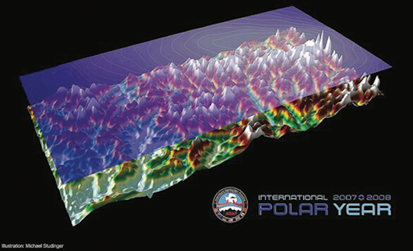
The Gamburtsev Mountain Range is about the size of the European Alps and are as rugged as the Rocky Mountains. Why has no one ever seen the mountain range? Because it's buried underneath 10,800 feet of ice in Antarctica.

Oh, and water flows uphill there.

One of the more interesting aspects of the Gamburtsevs is the ruggedness to them. They're more than a hundred million years old. By now they should have eroded enough to resemble the Appalachians, instead of looking like the Rockies.

Scientists today think the mountain range has actually been preserved by the ice above it—a counter-intuitive result, since absolutely nothing erodes mountains faster than glacial ice in normal circumstances.

The Antarctic ice sheets are so thick, however, that the ice starts to behave in a bizarre manner. As the pressure grows stronger farther and farther down into the ice sheet, the freezing point of water starts to drop lower and lower, until liquid water eventually exists at the bottom; the freezing point of water down there is simply just too low. The pressure actually forces the water to flow uphill!

We've identified other mountain ranges that were presumably buried underneath ice sheets during the Ice Age, including the Torngat Mountains in Canada and the Scandinavian Mountains.

If the ice in Antarctica ever melts, one effect will be that the mountains (currently with an average height of 8,850 feet) would rebound upwards. Ice sheets are so heavy that they actually press the continental crust downward into the mantle.

Removing the Antarctic ice sheets would cause the Gamburtsevs to rebound back up to 10,800 feet in height.

Thankfully, we're not likely to see them any time soon. Even the worst models for global warming don't predict that rebounding scenario as extremely likely. Which is a good thing because it would raise the sea level some 200 feet.

_________

Quotable

Dear Yard Ramp GuyOh yes—a quote for you:

“O, what a tangled web we weave; When first we practice to deceive!”
— Sir Walter Scott

Norwegian Gratitude

Seeding the Svalbard Archipelago

Svalbard Vault Entrance

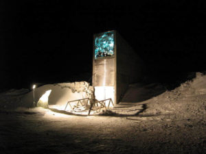
Entrance to the Svalbard Vault

These days, we’ve come to expect powerful governments and military forces building bunkers underneath mountains.

For example, China has an underground network of tunnels for ferrying nuclear weapons, and the United States has a vast operations center for NORAD under Cheyenne Mountain.

One of the most secure of all these underground facilities is somewhat surprising, though. The Norwegians built it, and they use it for plants.

They constructed the Svalbard Global Seed Vault to hold a wide variety of plant seeds that are duplicate samples of seeds held in gene banks from around the world.

Its intended purpose is to provide a form of insurance: as a backup should we lose other seed gene banks or if we experience large-scale crises on a regional or global scale.

By request of the Norwegian government, the vault holds no genetically modified seeds. Engineers built the structure 390 feet inside a sandstone mountain on the Svalbard archipelago, an Arctic island chain that is one of the coldest places on the planet.

Svalbard lacks tectonic activity, ensuring the vault is safe from earthquakes. The surrounding permafrost helps keep the vault cool; even if the refrigeration units failed, it would take several weeks for the facility to rise to the surrounding sandstone's temperature, which would remain below freezing. And the bunker is 430 feet above sea level, so even if the ice caps completely melt it won't be flooded.

The vault's primary purpose isn’t to provide new seeds to a region facing a major disaster (though it can do that in a pinch). Instead, Svalbard is there to restock smaller gene banks around the world in case they've been affected by a disaster or have lost seeds to mismanagement.

It's best to think of it as a bank to which other banks can make deposits (those being the world's 1,750 other seed banks).

In fact, they're often called to do so: in 2012, the Philippines lost its entire seedbank to flooding and fire and received assistance from the Norwegian initiative.

_________

Quotable

Oh, Yard Ramp GuyPlease regard my reverse-alphabetical entry this week...

“Plenty of people miss their share of happiness, Not because they never found it, But because they didn't stop to enjoy it.”

— William Faulkner

The QWERTY Blues

Or: Was the Dvorak Like Betamax?

QWERTY keyboard

Just My Type

The first time I asked someone why the letters on a keyboard were positioned the way they were, I heard that it was organized in the QWERTY format to slow typists down in order to prevent the keys from jamming.

This was only a few years ago (so many topics and so much information to explore: for some reason, I'd just never wondered about it before then), and typewriters were long out of vogue. This, of course, led to the question of why the keyboard hasn’t really changed.

The standard explanation for QWERTY sticking around has to do with institutional inertia. Once an organization, company, or even nation is accustomed to using a specific system, switching over becomes much, much harder. There are retraining costs, equipment replacement costs, and plenty of people who just don't like change. (And yes, in all fairness: I'm one of them, half the time.) It's the same reason that the United States is one of the only countries to not have switched to the metric system.

There are alternatives to QWERTY, of course. Dvorak is the best known instance. Dvorak claims to gain greater accuracy and speed in typing by moving the vowels to home row and by making sure the most frequently used letters were on the right side of the keyboard, among other changes.

Well, it turns out that the whole QWERTY origin story was actually wrong. Typewriter design flaws weren't responsible for the QWERTY keyboard layout. In fact, it was actually designed to be more efficient for telegraph operators—the letter positions were arranged to work better for the particular quirks of Morse code, stretching back to the very first mass marketed typewriter.

What about Dvorak? Well, it does seem to provide a small typing speed advantage…but not a significant one. It turns out that most of the studies about Dvorak were pretty poorly run; Dr. August Dvorak, the Dvorak’s creator ran the most famous study—yes, it showed the Dvorak in an extremely positive light.

And the small typing speed advantage it offers certainly doesn't counterbalance the literal billions it would cost to retool the computers in America alone.

Anyway, if we were really that worried about faster typing speed, we'd just switch to stenography instead, which more than triples the speed of Dvorak or QWERTY.

No offense to Dvorak or stenography, but I'll stick to the keyboard that came with my computer.

_________

Quotable

Okay, (other) Yard Ramp GuyQuestion it all, my friend:

“Quality is never an accident; it is always the result of intelligent effort.”

— John Ruskin

Free Software

Well, Kind Of…

open source

Lost in the (Free) Matrix

Many people don't realize it, but the most important software in the world is free.

Various open source programs (called such because their code is available for anyone to download, examine, or use) form the backbone of the Internet. Nearly all the programs that allow the internet to run are completely free, with volunteers maintaining many of them.

Open source software also has a wide array of other functions. You can find free open-source versions of most types of programs. Here are a few of the more useful ones I've stumbled across over the years:

Apache Open Office | A full open source office productivity suite, Open Office is fully capable of replacing the entire Microsoft Office Suite with ease.  You can still open, edit, and save files in Microsoft Office formats, as well as in a variety of others. Includes the obligatory word processor, spreadsheet program, and slideshow program. I've been using this one for years.

GIMP | GIMP is an excellent open source alternative to Photoshop. Though it used to have a reputation as clunky, cluttered, and hard to use, GIMP has since developed into a much more streamlined and user-friendly experience. It's widely considered an acceptable alternative, even by industry professionals.

QGIS | Also known as Quantum GIS, QGIS is the fastest and most powerful open source GIS (Geographic Information System) on the market. While ArcGIS, the dominant program on the market, is a bit more versatile, it also costs thousands of dollars and often runs a tad slower than QGIS. If you need to create, examine, or alter maps for free, QGIS is your best bet.

FreeCAD | FreeCAD isn't quite as polished as some of these other options yet remains a good choice for someone looking for an open source alternative to AutoCAD, or the like, for design work.

Oh, a big caveat here: yes, these are all free…though you’ll have to pay hundreds of dollars, along with monthly fees to your Internet service provider, in order to run the stuff.

_________

Quotable

Yes, Yard Ramp Guy. Quotations truly do R-esonate with me:

“Rage is the only quality which has kept me, or anybody I have ever studied, writing columns for newspapers.”

— Jimmy Breslin

Aral Sea Woes

In Uzbekistan No One Can Hear Fish Scream

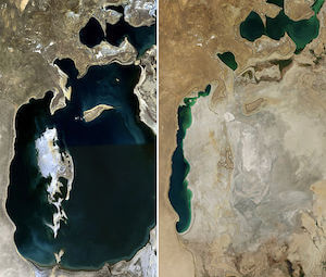
The Aral Sea: 1989 (l) and 2014 (r).

In the early 1960s, the Aral Sea—in between today's Uzbekistan and Kazakhstan—was one of the four largest lakes on the planet. By 2007, it had reduced to ten percent of its former size.

The Aral Sea's name roughly translates to “The Sea of Islands,” a reference to, shockingly enough, its many islands. It played a vital part in the region's history, economy, and culture, as well as feeding much of the region with rich fisheries. And then, in the early 60s that started to change.

The Soviet Union began a series of projects in the region. The largest of these was the diversion of the two main rivers that fed the Aral Sea, the Amu Darya and the Syr Darya, for the purposes of agricultural irrigation.

The USSR planned to use the water to turn the region into one of the world's largest cotton exporters, and this actually worked, for a little while. As many of the irrigation canals were poorly constructed, they often lost as much as 75% of the water flowing through them.

And so the Aral Sea began a slow but steady decline in water level. The rate of evaporation increased as more and more water was taken from the rivers for irrigation purposes. The Soviet Union was aware that the lake would disappear. They simply weren’t concerned. As more water evaporated and wasn't replaced, the salinity of the lake steadily increased, by almost 500%.

By 2007, at ten percent of its normal size and split now into two lakes, the North and South Aral, it had a salinity almost three times that of the ocean, killing almost all its natural life. (Though it still wasn't as salty as the Dead Sea.)

The huge plains left as a result of the sea evaporation are coated with salt and toxic chemicals (weapons tests, industry, and agricultural runoff.) These nasty sediments are picked up by the wind and carried great distances, causing cancer and other ailments all over the region. There's so much of the toxic dust that the region now regularly has poisonous dust storms.

Some conservation efforts have slowed the evaporation of the sea. Engineers have begun to repair and strengthen the irrigation canals in order to minimize the losses through them. The northern half, in Kazakhstan, has been dammed off from the southern half, resulting in a rise in sea level in the northern half, with salinity levels dropped to the point where life can survive there again.

There's little hope for the southern half. Uzbekistan has no interest in reducing its irrigation demands, or efficiency, and has instead begun working on exploiting the exposed seabed for oil.

_________

Quotable

Okay, Yard Ramp Guy — S-omething to quote (in case yours isn’t quotable):

“Sadness is but a wall between two gardens.”

— Kahlil Gibran